
The earthquake that hit Japan’s northeast coast today had a magnitude of 8.9 in the Richter scale and generated a 4-metre tsunami that swept boats, cars, buildings and tons of debris miles inland. Fires triggered by the quake burned out of control up and down the coast. Only a couple of days ago, I read in a web news page from my town of origin in Brazil (Montes Claros) about a less powerful earthquake, which happened there, but happened very deep in the earth, and posed no risk to residents or structures, although people felt the tremor and wondered if another more powerful earthquake was on the way. These events made me wonder if there’s a way for the general public to find out in advance if their area of the world is at risk. I made a search in Cabidirect.org and found over 600 records on earthquake and nearly 250 on tsunamis.
One of these records is a paper entitled 'The PREVIEW Global Risk Data Platform: a geo-portal to serve and share global data on risk to natural hazards', by G. Giuliani and P. Peduzzi, from the United Nations Environment Programme’s Division of Early Warning and Assessment of the Global Resource Information Database, in Geneva, Switzerland. The paper was published in Natural Hazards and Earth System Sciences 2011 Vol. 11 No. 1 pp. 53-66.
The description of the platform says that “The PREVIEW Global Risk Data Platform is a highly interactive web-based GIS portal supported by a Spatial Data Infrastructure that offers free and interoperable access to more than 60 global data sets on nine types of natural hazards (tropical cyclones and related storm surges, drought, earthquakes, biomass fires, floods, landslides, tsunamis and volcanic eruptions) and related exposure and risk. This application portrays an easy-to-use online interactive mapping interface so that users can easily work with it and seamlessly integrate data in their own data flow using fully compliant OGC Web Services (OWS).”
I had a browse of the platform and found that I would have to pay to extract information on countries I picked, which I suspect is probably because it is aimed at organisations that have to be members to use the information for free. It states that “it is a multiple agencies effort to share spatial data information on global risk from natural hazards. Users can visualise, download or extract data on past hazardous events, hazard exposure and risk from natural hazards.” Nevertheless, I found a link there to the more interactive United States Geological Survey (USGS) web page, which provides a lot of information about earthquakes for free, including a facility to sign up and receive earthquake notifications by email.
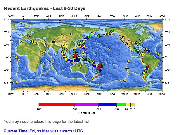
The USGS also provides earthquakes lists and maps, like the one copied above (courtesy of the USGS), and a seismogram display in real time. The labels in the above map are colour-coded according to the earthquake depth, with yellow being nearer the surface and, depending on the magnitude, may cause a lot of damage, while the red dots are those much deeper down in the earth and might not affect structures on the surface.
Japan lies in one of the world's most seismically active areas, between four major continental and oceanic plates (the Pacific Plate, Philippine Plate, Eurasian Plate and North American Plate) and accounts for around 20% of the world's earthquakes of magnitude 6 or bigger. Athough Japan is well prepared for earthquakes, this latest one was the strongest on record for Japan and one of the world's five most powerful earthquakes since modern seismological record-keeping began. The resulting tsunami and the devastation it caused was probably the worst faced by Japan.
Link to the PREVIEW platform
Link to the USGS earthquake page http://earthquake.usgs.gov/earthquakes/shakemap/list.php?y=2011&n=global
Link to Cabdirect search results, for subscribers.
1 Comment
Leave a Reply
Extremely interesting post with a great deal of very well researched and timely information. With the Japan earthquake, there is a high awareness about disaster readiness and awareness. Thank you for sharing your great insights and expertise in this area.